
MAA NARMADA
Mythology
The Narmada River is considered the mother and giver of peace. Legend has it that the mere sight of this river is enough to cleanse one's soul, as against a dip in the Ganga or seven in the Yamuna. The Ganga is believed to visit this river once a year, in the guise of a black cow to cleanse herself of all her collected sins.The journey along the river Narmada is in some sense similar to famous parikrama (taking round) of the river, except that the parikrama is of life in the valley of the Narmada.
Along the River
Narmadakund in Amarkantak has an ambience that makes a pilgrim spot out of this small place. Amarkantak is a plateau from which hangs a tale.
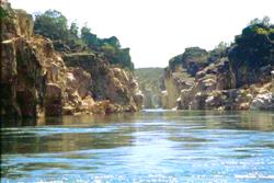
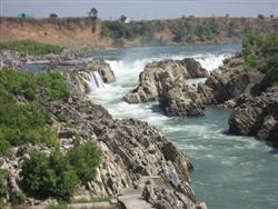
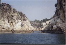
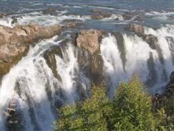
Young Narmada falls in love with the male river Son and asks Juhilla (a tributary of the Son) to convey her message of love. Juhilla entices Son herself. The disgust and anguish of the lovely Narmada compels her to jump off the western cliffs of Amarkantak. A mere six kilometers from her genesis, the Narmada hurtles down 150 feet at Kapildhara, a gorgeous waterfall. Named after the saint Kapil, this fall is soon followed by Dudhadhara. All along the river, one will be always close to teak jungles. Apart from teaks, India's best hardwood forests are found in the Narmada river basin and they are much older than the ones in the Himalayas. Moving along, one reaches the marble rock country Bheraghat near Jabalpur . Bheraghat, about 24 km away from Jabalpur , is a cluster of great, white limestone cliffs standing out 30 m above the waters of the Narmada. They are an awesome sight, particularly by night when white, silvery moonshine bathes the gorge. The views at Dhuandhar, where the river is more like a screen of mist, and Haathi-ka-Paon are mesmeric.
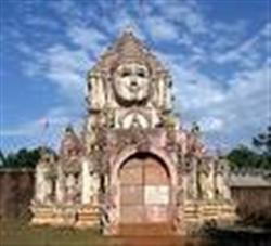
There is the Chausath Yogini (sixty-four yoginis) temple above the lower end of the gorge. The attendants of Durga are represented here. Although the images have been damaged, they still retain their pristine beauty.
The city of Jabalpur is the second largest in Madhya Pradesh after Bhopal. The metropolis itself stands in a rock basin about 10 km away from the Narmada. Named after a saint called Jabali who lived here, Jabalpur is famous for its marble rocks.
Down the Narmada, it is a myriad landscape-thickly forested mountain slopes, rocky regions with picturesque rapids, falls and whirlpools and cultivated lands with rich black cotton soil. The great river runs through rift valleys, which are part of perhaps the oldest geological formations of India. Believed to have originated from the body of Shiva, the river is also known as Jata Shankari. The worship of Shiva is common in these areas, and each stone or pebble found in the bed of the Narmada is believed to be a Shivalinga. Places along the banks-Omkareshwar, Maheshwar, and Mahadeo-are all named after Shiva.
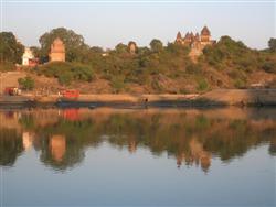
Omkareshwar has several old and new temples. There is an island on the river that is supposed to have one of India's twelve great Shivalingas. Maheshwar is on the northern banks of the river. Cenotaphs in memory of the Holkars beautify the landscape at Maheshwar. There are a number of temples too, and a fort. One also gets a chance to see the delicate, gorgeous Maheshwari saris being hand-woven. Comfortable in warm and cold weather, dressy and yet light, these saris have a dedicated, select following among Indian women. Places like Maheshwar and Omkareshwar are just examples of the large number of religious centers that dot the banks of the Narmada as it weaves its 1,000-kilometer journey through the state of Madhya Pradesh
To this Narmada, home to so many, religion to more, and beautiful river to all, there are many odes. The best ode would be a sojourn for a real experience that can last a lifetime.
MAA NARMADA : A journy to life
The Narmada River is the only river in India that flows in a rift valley and is a traditional divider between North India and South India. It is one of only three major rivers in peninsular India that run from east to west, along with the Tapti and the Mahi river. The river rises on the summit of Amarkantak Hill in Madhya Pradesh state .It traverses the first 320 kilometers (200 miles) course around the Mandla Hills, which form the head of the Satpura Range; then moves towards Jabalpur passing through the `Marble Rocks`, it enters the Narmada Valley between the Vindhya and Satpura ranges, and moves westwards towards the Gulf of Cambay. It flows through the states of Madhya Pradesh, Maharashtra, and Gujarat, and finally meets the Arabian Sea in the Bharuch District of Gujarat.
The Narmada river is considered extremely holy by the Hindus. It is believed that just the sight of the river cleanses one of all sins.It is closely associated with Lord Shiva believed to be descended from the sky. It is said that the mere sight of the river will make a pilgrim pure because of its sanctity. As a result, the river represents an important pilgrimage site, and one of the highest acts a pilgrim can perform is to walk from the sea to the source of the river, in the Maikal Mountains and back along the opposite bank, a process that takes approximately two years to complete. The town of Maheshwar is a particularly important pilgrimage site along the route of the river.The Narmadeeya Brahmins worship the Narmada as Mother Goddess.Reva is another name of the river.History shows that the Aryans settled on the banks of the Narmada as they expanded eastwards.
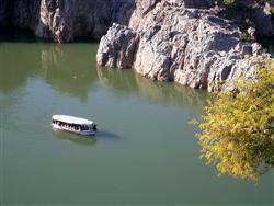
The river has beautiful ghats built on its banks in Hoshangabad. Its longest tributary is the Tawa, which joins the Narmada at Bandra Bhan in Hoshangabad District, Madhya Pradesh. After leaving Madhya Pradesh and Maharashtra, the river widens out in the fertile district of Bharuch. Below Bharuch city it forms a 20 kilometre wide estuary where it enters the Gulf of Cambay.The water of the river is used not only for feeding the drought prone areas of Gujarat and Madhya Pradesh,but also for navigation as well. In the rainy season boats of considerable size sail about 100 kilometres above Bharuch city. Seagoing vessels of about 70 tons frequent the port of Bharuch but such navigation depends on the tide.
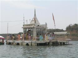
The place of origin of Narmada River is an open pool known as Narmadakund. Around this kund there are several beautiful temples such as Narmada and Shiva temple, Kartikey temple, Annapurna temple, Shri Ram Janki temple, Guru Gorakhnath temple, Sri Shuryanarayan temple, Vangeshwar Mahadev temple, Durga temple, Shiv Pariwar, Siddheswar Mahadev temple, Sri Radha Krishna temple, Eleven Rudra temple etc. The spot of River Narmada`s origin is considered as a religious ground. Narmadakund is an open pond, lying at the starting point of the Narmada River. Various temples of particular Hindu God and Goddesses encircle this pond. The religious fervor of the tourists are easily satiated in this place.
The history of Narmada River is closely associated with the place Amarkantak and Narmadakund. Amarkantak and rivers originating from it are hardly mentioned in Vedic literature, but these have been mentioned many a times in Puranas, Ramayana, Mahabharata, Vashishtha samhita and "Shatapatha Brahmana". After Mahabharata the history of a period of about 3000 years remains in dark. Professor Arjun Chaube Kashyap came to a conclusion that the Puranic name of Amarkantak was Riksh parvat. About 6000 years back the Suryavanshi samrat Mandhata established a town in the valley Riksh parvat and called it Mandhata. The queen of samrat Purukutsa, who was son of Mandhata, gave the title of Narmada to the river. Due to occupation of this area by Mandhata the descendents of Yayati migrated from this area to west of Madhya Pradesh and settled on the banks of Narmada River.
The surrounding natural landmark forms the geography of Narmada River. The Narmada Valley is one of the vital forms in the geography of Narmada River. Below the Vindhyachal scarps, the narrow valley of the Narmada lies. The River flows across this valley and the valley occupies the southern part of the district in Manawar tahsil and the southeastern part of Kukshi tahsil. The width of the valley is 15 to 30 kilometers. The height varies from 275 meters in the northern part of Manawar tahsil to 150 metres in the low plain of Nisarpur in the southwest. Khalghat and Bakaner lie in the western side of the valley and the valleys is undulation wider, more open and fertile with alluvial cover. Proceeding westwards the valley is embedded with hills alternatively give birth to numerous streams, which join the Narmada along the southern boundary of the district. The result is that there are few stretches and pockets of alluvium silt along the streams.
The geology of Narmada River Valley says it a graben. A graben means a layered block of the earth`s crust that dropped down comparatively to the blocks on either side due to ancient spreading of the earth`s crust. Two normal faults, known as the Narmada North fault and Narmada South fault, parallel to the river`s course, and smear the boundary between the Narmada block and the Vindhya and Satpura blocks or horsts which rise relative to the Narmada Graben. The Narmada`s watershed includes the northern slopes of the Satpuras, and the steep southern slope of the Vindhya Range; however, not the Vindhyan tableland and the streams from which flow into the Ganges and Yamuna. The Narmada valley is considered very significant for paleontological studies in India.
The religious significance of Narmada River lies in its origin. The river is one of the most sacred of the five holy rivers of India; the other four sacred rivers of India are Ganga, Yamuna, Godavari and Kaveri. It is believed that a dip in any of these five rivers washes ones sins away. Ptolemy has mentioned the river in the 2nd century AD as Namade. The Ramayana, the Mahabharata and Puranas refer to it often. The Rewa Khand of Vayu Puran and the Rewa Khand of Skand Puran are completely devoted to the story of the birth and the significance of the River and hence Narmada is also called Rewa.
The course of River Narmada starts with its origin at a small tank called Narmada Kund located on the Amarkantak hill (at an height of 1057 m above sea level) in the Shahdol district of eastern Madhya Pradesh. The river flows down from the Amarkantak hill range at the Kapildhara falls over a high cliff and meanders down the hills flowing through a twisting course and crossing the rocks and islands up to the ruined palace of Ramnagar. The river flows further between Ramnagar and Mandla 25 km in the direction of southeast. The river course of Narmada is comparatively straight with deep water and there are hardly any rocky obstacles.
The valleys of River Narmada are not only historically important, but also economically. In the present days, these valleys are bases for various handicraft works and other small-scale industries. In Indian history, Chalukya emperor Pulakeshin II was known to have defeated emperor Harshavardhan of Kannauj on the banks of Narmada.
There are several forests and sanctuaries along the River Narmada and they are some of the distinguished ones in India. Teak and India`s best hardwood forests are found along the Narmada River and are affluent in the basin. Moreover, these teak trees are much older than the ones in the Himalayas.
The anthropological sites along River Narmada not only serve for the historians interest but also the tourists. The extensive caves of Bhimbhetka are located in a dyke structure of the Narmada valley at about 45 km northeast of Bhopal. These caves lie between Bhopal and Hoshangabad highway and depict pre-historic rock shelter paintings. These paintings are considered a priceless chronicle in the history of man, which are sculpted on the summit of the Vindhyan heights. The caves of Bhimbhetka were discovered in 1957-58 and is a natural art gallery and an archaeological treasure.
The Narmada river development or NRD are the policies and rules to keep the banks of the river clean and developed. The Narmada River features huge resources and potential for the development of the region. The Narmada river development was designed to keep the banks and water of the river clean and usable for resource needs. The Narmada River has a huge water resources potential, as high as 33.21 MAF (41,000 M.cum) of average annual flow. More than 90% of this flow occurs during the monsoon months of June to September. The annual flow estimated is greater than the combined annual flows of the rivers like Ravi, Beas and the Sutlej, which feed the Indus basin.
The early background and dispute of River Narmada have emerged with many advanced plans for the development of the basin. Explorations for using the Narmada waters had began around the time of independence, when Central Waterways, Irrigation and Navigation Commission or the CWINC came up with several storage schemes. In 1948 the Khosla Committee prioritized the proposals and named Tawa, Punasa, Bargi and Bharuch projects for preparation of reports. The needed reports were ready by 1963. A comparable study of the Hydropower potential recognized 16 sites with a power of 1300 MW.
The navigation along the River Narmada is at its best nowadays. The river is presently partially navigable in the estuary reach around Bharuch. However, the river has never been a transportation artery. The idea for inland navigation came from NWDT thus giving its award for the two main dams, namely the Sardar Sarovar in Gujarat, built 180 km from the coast and the Narmada Sagar in Madhaya Pradesh. These two dams are separated by a river with a distance of about 900 km, and the plans to build two other dams in between of the main stem of the river.